

Another menacing storm front moved through Southern California on Thursday, bringing rain, flash flood concerns, strong winds and dangerous surf as the region was still reeling from a moisture-rich atmospheric river that pounded the entire state in recent days.
But the heavy rains seemed to break for much of Southern California by noon, even offering a glimpse of sunshine after a wet and at times dangerous morning.
The cold front and heaviest rainfall moved through the Los Angeles area faster and earlier than expected and produced less rain, dropping about 1 to 2 inches at lower elevations and 2 to 5 inches at higher elevations, meteorologists with the National Weather Service in Oxnard said.
But the region remained at risk of isolated thunderstorms and flooding through Thursday because of a cold air mass traveling in the front’s wake, meteorologists said.
A flood watch issued Wednesday across southwest California was canceled by noon Thursday, after the strongest part of the storm had moved out of Los Angeles County. The flood watch was canceled for San Luis Obispo, Santa Barbara, Ventura and Los Angeles counties, according to the National Weather Service.
But the heavy rains didn’t clear without first inflicting damage on the region, prompting road closures, water rescues and evacuations as emergency personnel monitored rapidly rising river waters.
A member of the Ventura County Fire Department hangs from a helicopter during a rescue operation Thursday on the Ventura River near Stanley Avenue.
(Ventura County Fire Department)
In Ventura County, firefighters rescued five people from rising river waters in three different operations.
One video posted online by the county Fire Department showed a helicopter rescue of a person who had been trapped as the Ventura River flooded. The person “was holding onto bamboo branches” before being lifted to safety, according to the Fire Department.
After the rescue, firefighters searched the area but found no one else in need of help, said firefighter Andy VanSciver. But officials returned to the same area hours later when a group of people appeared to be trapped on an island in the middle of the river.
Two were able to get to safety on their own, but another had to be helicoptered out.
Just before 3 pm, firefighters were dispatched again — this time for people who appeared to be stranded in the Santa Clara River, about a quarter of a mile downstream from the 101 Freeway, VanSciver said. Three people had to be lifted to safety.
None of the people rescued Thursday appeared to be seriously injured, he said.
In San Bernardino County, more than 4,000 Southern California Edison customers lost power in Yucca Valley. David Song, a spokesperson with the utility, said the outage was caused by equipment failure that was likely caused by the storm. The outage was reported at 11 am, and power was not restored until 3:30 pm, he said.
Along the coast, lifeguards watched as 8- to 12-foot waves hammered beaches, at times reaching the lifeguard towers placed along the sand.
In preparation for the storm, lifeguards had already moved several towers back from the water, at times near bike paths off the sand, said Capt. AJ Lester with the Los Angeles County Fire Department lifeguard division. On Thursday morning, they moved another 15 to 20 after waves crept up.
“We’ve seen quite a bit of beach erosion,” he said. “We had to move them back to keep them from ending up in the ocean.”
Tall waves were scraping the bottom of piers in Manhattan Beach, Hermosa Beach and Venice Beach, spurring city officials to close them, Lester said. The piers were expected to remain closed through Saturday.
A winter storm warning was issued for the mountains of Los Angeles and Ventura counties through 10 pm Thursday, with up to a foot of new snow expected at some of the highest elevations, with wind gusts reaching 55 mph.
High surf was expected to peak Thursday night, with waves of up to 16 feet possible along the Ventura County coastline and up to 12 feet in Los Angeles and Santa Barbara counties. Malibu and Zuma beaches had reports of some coastal flooding early Thursday. Meteorologists expected significant beach erosion, particularly at high tide. Los Angeles County is offering sandbag pickup at a number of locations.
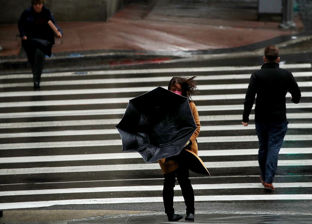
A gust of wind blows a pedestrian’s umbrella inside out in downtown Los Angeles on Wednesday.
(Luis Sinco / Los Angeles Times)
“Here in Southern California,” said Ariel Cohen, a meteorologist with the National Weather Service, the storm system was “certainly one of our strongest.”
Forecasters had warned of mud and debris flows at the Fish and Bobcat fire burn scar areas near Duarte and the Route fire burn scar areas near Castaic Lake.
Duarte officials, who had placed the Fish fire burn area under its “yellow alert level” starting Wednesday evening — which included restricted parking — moved the area to a lower alert level by Thursday evening and lifted the parking restrictions.
“Overall, Duarte experienced very little impact in the Fish fire area with only minor dirt and debris behind the k-rails at the top of Mel Canyon Road,” city officials said in a release.
The Lake fire burn scar around Lake Hughes, north of the Santa Clarita Valley, was a cause of concern Thursday. Los Angeles County officials at one point warned residents in that area and in and around the Angeles National Forest to be ready for possible evacuations through Friday morning.
The Sepulveda Basin was closed early Thursday due to high water levels, and multiple streets were flooded in Los Angeles, according to the Los Angeles Police Department.
A landslide closed both directions of Topanga Canyon Boulevard from Pacific Coast Highway to Grand View Drive on Thursday afternoon. Photos from the California Department of Transportation showed a large boulder and other debris in the roadway, which officials said was expected to remain closed until Friday morning.
Though the rainfall totals were below expected amounts, “accidents and traffic collisions are everywhere” around Los Angeles, said Officer Moises Marroquin, of the California Highway Patrol. He said highway flooding was pervasive.
The Los Angeles County Sheriff’s Department Lost Hills Station said in a tweet that downed trees and small rock slides were reported across the area and advised residents to stay home. Beverly Hills also had reports of large fallen trees.
In a period of less than 48 hours after the latest storm moved in, downtown Los Angeles had received about 0.67 inches of rain, while Beverly Hills came in at 1.8 inches. About 2.96 inches of rain fell on Woodland Hills in the San Fernando Valley, and Newhall in the Santa Clarita Valley recorded about 1.69 inches. Rainfall totals at higher elevations exceeded 3.5 inches in some areas, including the Lechuza fire station in the Santa Monica Mountains.
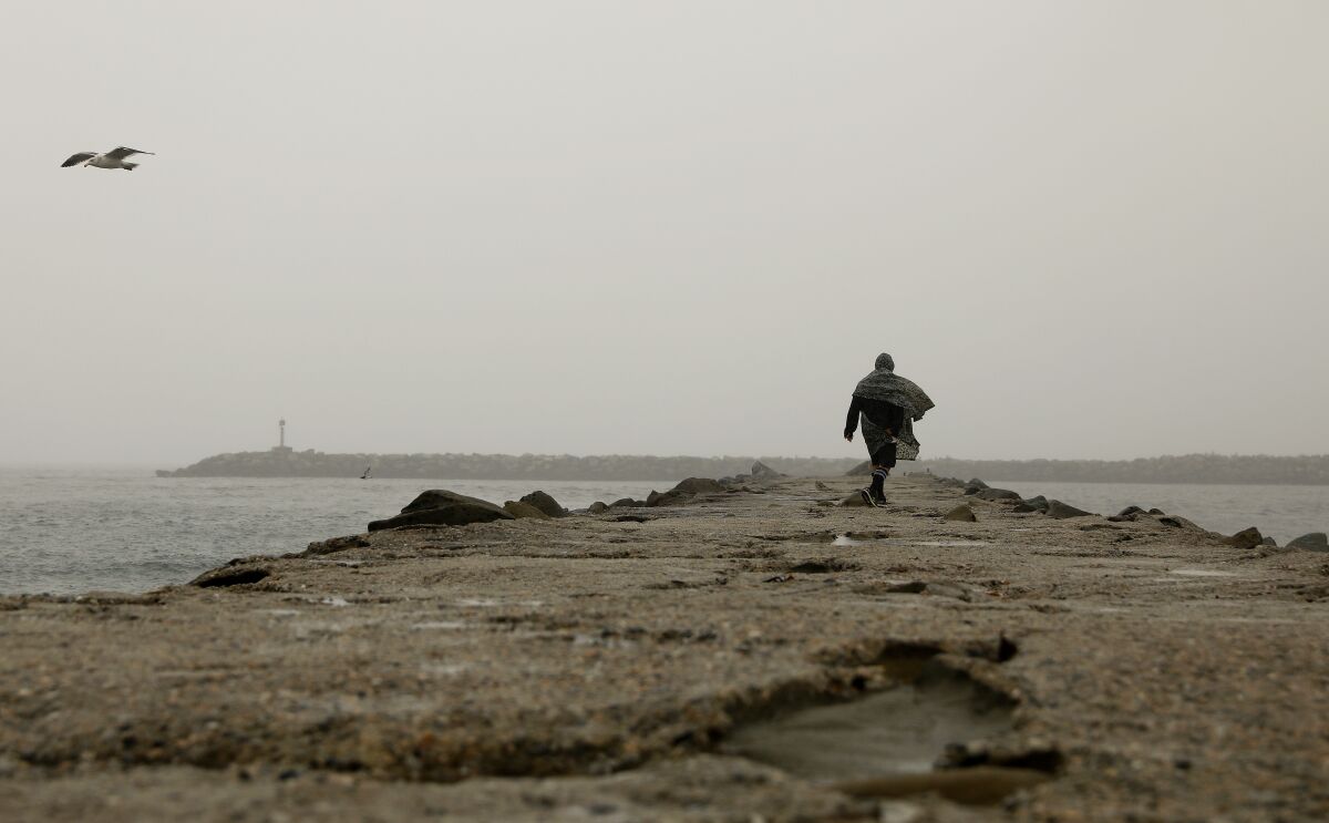
Chris Rohloff of Venice walks along a jetty by Ballona Creek to check out the surf Wednesday.
(Christina House / Los Angeles Times)
Eagle Rock Reservoir recorded 1.11 inches, and Pasadena reached just 1 inch.
Thursday’s storm came on the heels of a series of storms — what experts describe as an atmospheric river — that had lashed California, prompting Gov. Gavin Newsom to proclaim a statewide emergency on Wednesday to “support response and recovery efforts” across the state.
In Northern California, where the storm has been most severe, pounding rain and strong winds Wednesday left a toddler dead, triggered evacuations and power outages, and heightened fears of widespread flooding and debris flows.
Though the storm was still significant in Southern California, the region has been spared the worst.
Southern California has been “more on … the southern periphery of the system,” Cohen said.
Officials in Santa Barbara County on Wednesday ordered the evacuation of areas previously scorched by the Thomas, Cave and Alisal fires, citing the risk of flooding and debris flows.
By Thursday morning, Santa Barbara officials lifted the evacuation order after the National Weather Service said the heaviest rains and the strongest winds associated with the storm had passed.
“Although showers and short-duration thunderstorms may produce short, heavy downpours, rainfall is not predicted to reach critical levels to cause flooding or debris flows,” the county’s Office of Emergency Service Management said in a message to residents.
Still, officials warned residents to remain cautious as they returned to their homes.
While rain was still pounding the region Thursday morning, the Santa Barbara County Fire Department was called to rescue two dogs trapped in the storm-swollen San Jose Creek in Goleta.
Both dogs “appear uninjured” and were reunited with their owner after being rescued, department public information officer Scott Safechuck posted on Twitter.
“Creeks and rivers continue to be dangerous from the storm event,” he wrote. “Please keep distance from all waterways during the rains and higher creek levels.”
Caltrans District 5, which includes Santa Barbara County, reported a full closure of Highway 154 Thursday morning between Highway 246 and Highway 192 because of multiple rock and mudslides. It remained closed until 3 pm, when officials announced that the debris had been cleared.
Light showers moved into Orange, San Bernardino and Riverside counties around 7 am, according to the National Weather Service in San Diego.
But the storm had already caused disruptions. In Orange County, flooding closed down Pacific Coast Highway between Warner Avenue and Seapoint Street, Caltrans District 12, which oversees Orange County, said in an early-morning tweet. By 3 pm, officials said the northbound lanes had reopened, but the southbound roadway remained closed until further notice.
Meteorologists received reports of downed trees in Burbank and warned of coastal flooding and erosion in other areas.
The storm also hit parts of San Luis Obispo County, where nearly 3,000 residents were without power early Thursday morning, according to PowerOutage.Us.
Forecasters warn there’s more to come.
“We have a parade of storm systems headed into the area over the next week,” Cohen said.
Times staff writers Grace Toohey and Luke Money contributed to this report.
Comments are closed.